Neat Data has partnered with CANA to develop a solution for the Colorado Mountain Club (CMC) to monitor and analyze the use and current state of outdoor recreation areas. CANA Advisors and CMC created the CMC Recreation Impact Monitoring Systems (RIMS) mobile app. The CMC RIMS App recently won the 2020 Public Lands Alliance (PLA) Innovative Product Award.
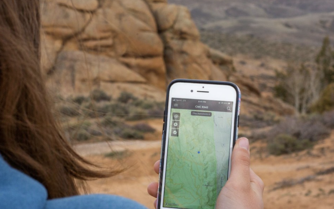
The CMC RIMS App allows trained volunteers to gather information about campsites, trail conditions, activity levels, and visitor use levels. Scroll to the bottom of the page to see a video by CMC about the app.
This post will share more information about the process and purpose behind the development of the program and app. We also want to illustrate one of the many use-cases for implementing a business analytics solution. In this project, Neat Data was integrated with the CMC RIMS mobile app, part of the CMC RIMS solution that our partner, CANA Advisors, developed and maintains.
To get a better understanding of this project, our marketing manager, Kristyn, interviewed Julie Mach, the Conservation Director at CMC who has been leading the charge on all things CMC RIMS.
Before we dive in to our conversation with Julie:
-
Anyone, anywhere can download the CMC RIMS mobile app for free to record data as they are using recreational areas. To utilize the app you must complete a brief 20 minute online training course.
-
If you are in Colorado, mark your calendars: May 16th is Colorado Public Lands Day! Julie and the CMC team are launching a RIMS data collection blitz between May 16 – Memorial Day, May 25. CMC’s goal is to get over 300 new users to download the app and collect data on visitor use during the COVID-19 pandemic. The data will help land managers understand where and how people are recreating while social distancing. Visit CMC’s Facebook event page to participate and learn more.
Chatting with Julie Mach about the Colorado Mountain Club (CMC) Recreation Impact Monitoring System (RIMS)
We’d love to hear you explain CMC RIMS in your own words. What does the data mean for CMC and why is it important?
Julie: RIMS is all about gathering data on public land so that land managers can do a better job of both understanding recreation levels and effectively using our resources for conservation. At CMC, our team is regularly hiking, skiing, mountain climbing, and more. Every time we interact with the environment we have an impact on that habitat – as users of public land we need to be responsible for that impact.
There isn’t a lot of good data on what that impact looks like. Land managers in charge of maintaining the land and natural resources are flying blind: they often don’t have the personnel or resources to regularly visit and monitor the trails and facilities they are tasked with managing. Land managers lack vital data about visitor use, traffic volume, current state of trails and campsites, etc, to make informed decisions to properly conserve the land and surrounding natural resources.
Our first goal was to find a way to collect all the data we need to make informed management decisions. Then we needed to pull that information in a way that land managers can easily make effective decisions. We worked with Norm Reitter at Sawatch Outliers to develop CMC RIMS, which is our data collection tool. Neat Data is the analytics component. By crowd-sourcing data through the CMC RIMS mobile app, Neat Data is able to process and and show the data in a form that land managers can interpret.
Congratulations, on CMC RIMS being selected for the Public Land’s Alliance Innovative Product of the Year Award! What was the inspiration for creating CMC RIMS?
Julie: The idea morphed slowly over time to become what it is today. CMC manages trail crews that go out and clear trail. We provide these crews as a resource to land managers who need assistance clearing trails. However, one recreation manager may be in charge of 500 miles of trail and that person hadn’t been on a trail for years. So decisions on what trail needed to be cleared and when was largely based on guesswork. Seeing this gap, we started having trail crews collecting data on the state of the trails as they worked and hiked to conservation sites.
Can you share examples of how you have been able to take action based on the data that is being collected using CMC RIMS?
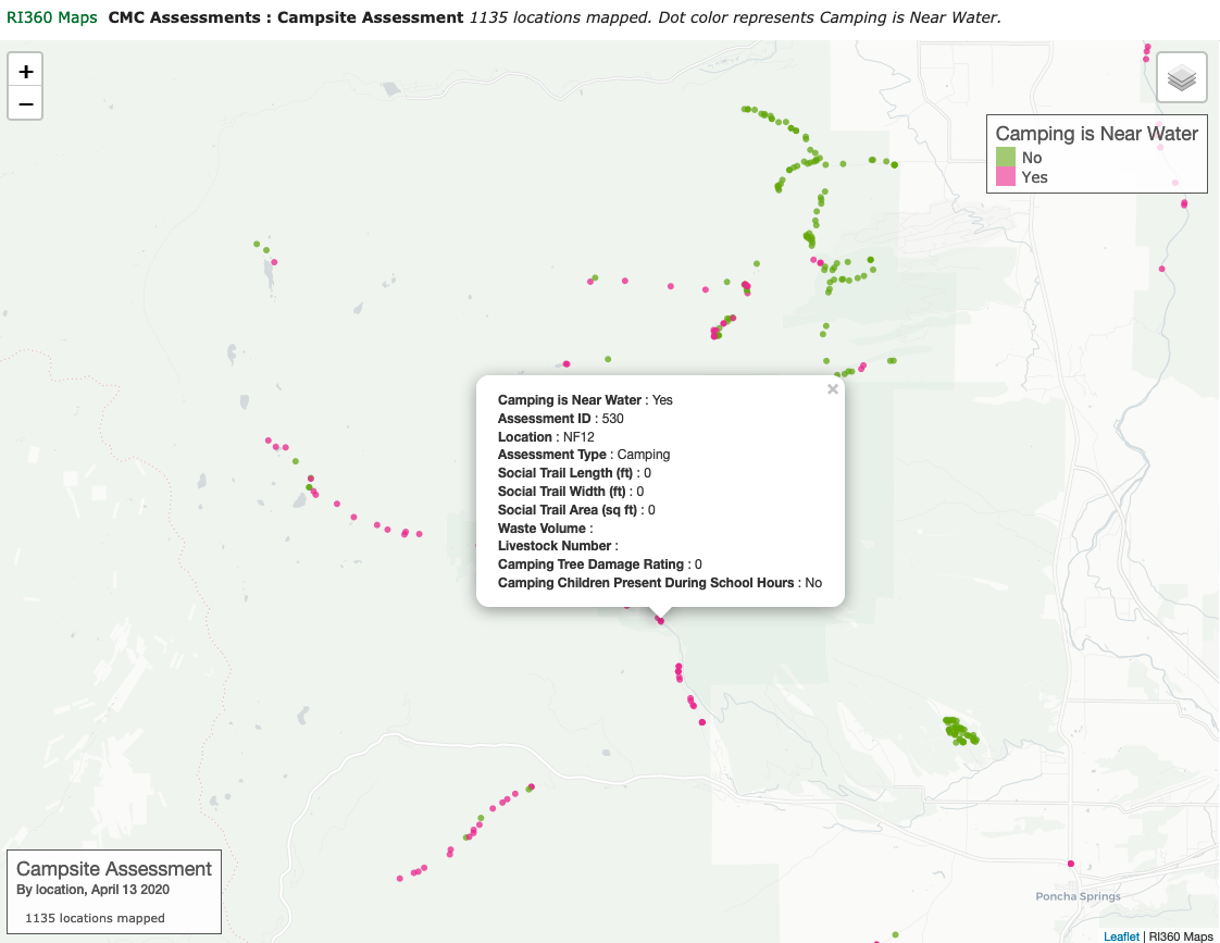
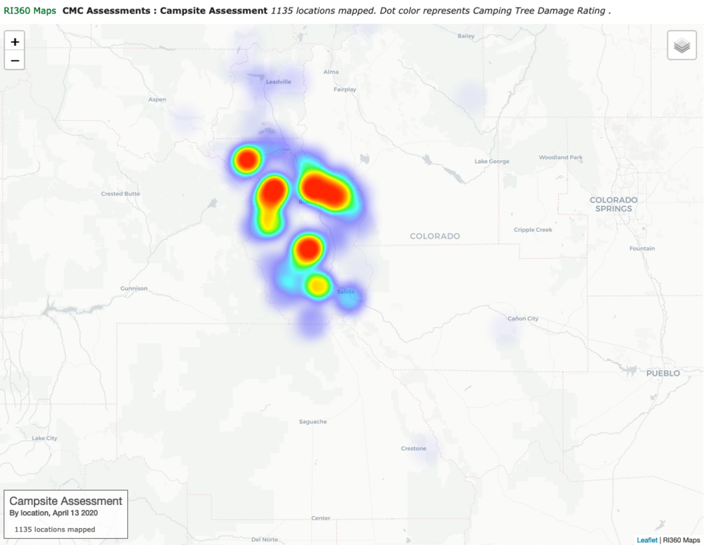
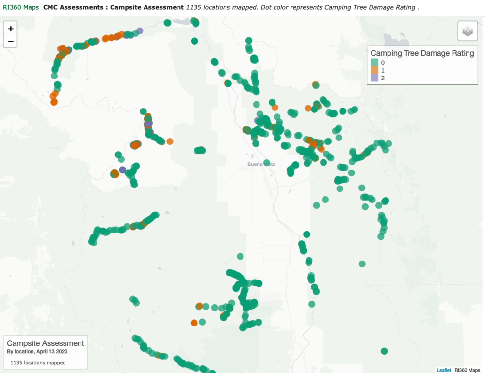
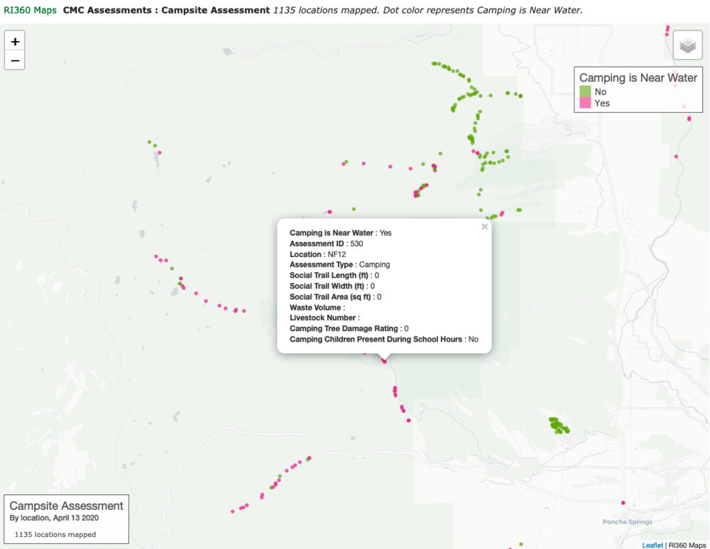
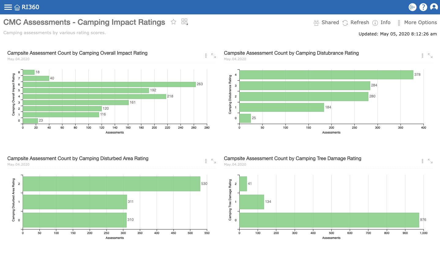
Julie: We ran our Pilot project in Chaffee County with the Recreation in Balance volunteer program. We asked the team of volunteers to do an assessment of 1000 campsites in Chaffee County. We trained a team of 120 volunteers, a majority of the assessments were done by 10-20. The assessments were done last fall, July – October 2019. Each assessment took 5-10 minutes and they were asked to record the condition of the campsites based on trash, campfire rings, human impact, etc. Since the completion of the 1000 assessments, our team has done a thorough review and analysis of the data they recorded to prioritize which campsites to address. We have a series of rapid response projects planned for this summer 2020 that include campfire ring dispersal, trash clean-up, and removing campsites.

How do you plan on utilizing the crowd-sourced data to achieve CMC’s conservation goals in the near- and Long-term?
Julie: Last year was our pilot year. We were fairly restrictive on how many people we wanted to use the app. We ended up with 300-400 users. Since then we have moved all our training online so it is much more accessible. We are gearing up to go fully public with the app itself. Our goal is to get over 1000 users on the app this year. We are especially focused on getting a wide variety of geographic distribution throughout Colorado so our data collection is more far reaching. More users = more data.
On the analytics side, we are building relationships with land managers who are looking for custom dashboards in Neat Data. Depending on where they are located, land managers have different focuses. Some may be more interested in dispersed camping, others on trail maintenance. There is a wide variety of what people are looking for in these dashboards and we are working to build them out.
How has your experience been using Neat Data to analyze data from CMC RIMS?
Julie: It has been really cool to learn – I can sure geek out on data stuff. It is great working with Chris. Our data set is fairly large and somewhat complicated – because it is coming out of the app we have to do some tweaking in the backend. Chris is very easy to work with – he understand what I need when I say I want to see the data a certain way and can implement fixes easily. I’ve also watched some of the video tutorials.
How much time do you spend playing with the data in your day-to-day work?
Julie: It varies – at least weekly. Sometimes I’ll be there everyday if I’m going in and building new dashboards. In preparation for our Data Blitz in May I’ve been logging in to Neat Data at least a couple of times a week.
Over the past few months, Chris and I have been checking in every other week. I’ll break something or can’t figure something out and we will meet and I will give Chris a list of things I need help on / need investigating.
Final Thoughts
Neat Data is excited to be involved in the CMC RIMS conservation project. It has been an engaging new application of Neat Data’s capabilities.
A large portion of our customer projects focus on using Neat Data to solve clients’ difficult business challenges. Partnering with Norm and Julie on CMC RIMS has been a unique opportunity to use the Neat Data’s business analytics platform to measure the impact of human recreation on our environment.